CASE STUDY: KAKUYUNI, KENYA
[Rewritten from: Jansens, 1991]
Landscape analysis
Physical features
Kakuyuni is located on the top of the Yatta plateau in a semi-arid climate zone, some 150 kilometres east of Kenya's capital Nairobi. The Yatta plateau is (on average) 5 kilometres wide and 250 metres higher than the surrounding rolling savannah landscape at an elevation of 1200 metres above sea level. The study area comprises a small water catchment and two plateau sections at both sides of the valley. The study area is almost rectangular and is 2 kilometres wide by 6 kilometres long. Slopes vary between almost flat to 40 percent. Soil erosion by water is a major land process.
Soils in the catchment area are well drained, vary from shallow to deep and are dark red, sandy clay-loams. The valley floor consists of sandy colluvium, as a result of sedimentation of debris from the severely eroding slopes. Rocky, shallow soils and gravels are found on the higher ridges and plateau edges. The plateau is characterised by depressions filled with vertisols. There is severe soil erosion in the valley. The climate of the area is characterised by a bi-modal rainfall pattern, with averages of 305 millimetres in the October-December season and 195 millimetres in the March-May season (Hoekstra et al., 1984). The rainstorms are unpredictable and locally variable. Generally, the intensity of the precipitation is high. The indigenous vegetation consists of dense shrubland of the Acacia-Commiphora type in the valleys and on the slopes, and a moderately dense savannah vegetation with trees, herbs, and grasses of the Acacia-Combretum type on the plateaus (Schork, 1980).
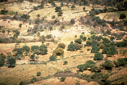
Gentle ridge/valley systems between Kanzulu escarpment and Athi Floodplain.
Settlement history
For the past 55 years, rapid population growth and decrease of productive arable land in Kenya's highlands have forced the Wakamba people to move to the unoccupied drylands. These dryland areas have much lower agricultural potential. In these areas, the Wakamba continue their system of permanent dryland agriculture combined with some livestock farming (Hoekstra et al., 1984). Currently, the population density in Kakuyuni is greater than the average population density of the whole agroclimatic zone. Since the 1950s, the catchment area has been gradually converted into a landscape dominated by human habitation. At present, all the land is occupied and legally adjudicated. The location of Katangi market and increased public and private services in the area have created new marketing opportunities for the farming community. This, in turn, has given the community freedom from their economic, social, and cultural isolation. Since 1984, however, the MIDP has withdrawn its control over the catchment area.
Assessment of needs, opportunities, and restrictions
Landscape pattern and agricultural systems
The landscape pattern of the study area is dominated by a more or less north-south running river valley, which forms a central axis in the area. Farm houses are scattered throughout the area , but tend to be concentrated along roads and paths.
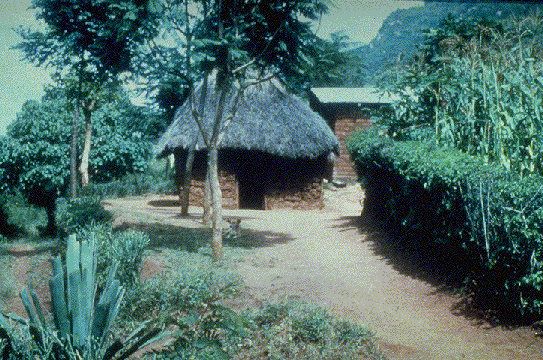
Typical farm compound: hedges and trees provide shade.
The inheritance system and recent land adjudication have caused a considerable fragmentation of land. Consequently, many small farms are surrounded by a patchwork of small remnants of the ancient bushland (often where soils are unsuitable for agriculture and where there are steep, rocky slopes), croplands, and grazing areas. The patchwork pattern which emerges is related through landforms, soil type, the accessibility of the terrain, and also to the proximity of the farm compounds.
The main land-use type in Kakuyuni is agriculture. Apart from arable cropping and livestock farming, families are engaged in farm forestry, charcoal production, woodcarving, beekeeping, brick making, and local construction works. Croplands are found on the undulating parts of the plateaus and on the upper and lower slopes of the valley. Grazing is spread all over the area and can be found predominantly on the slopes of the valley and on the crests, ridges, and depressions of the plateau. The bushland is used for browsing by goats and the collection of fuel wood.
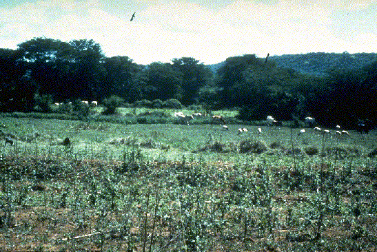
Cattle grazing in the floodplain of the Athi river.
Interviews with the farm families indicate that farm sizes vary considerably, ranging from about 3 hectares to nearly 120 hectares. About 75 percent of the farms are small (3-30 hectares). Observed landscape features were useful in distinguishing landscape units which were representative of existing farming systems and socio-economic differentiation within the farming community. Special attention was paid to two particular groups of farming families: the first generation of farming families, which is older, more experienced, and richer is located n the plateau; and the second generation farming families, young and relatively poor, are found predominantly in the valleys. The differences between the farming systems and the related landscape pattern is described in Table 1.
Processes and trends: needs, opportunities, and restrictions.
Both the landscape and society in Kakuyuni catchment are in rapid and perpetual change. Rapid population growth resulting from the settlement of new, young families and subsequently, a high birth rate and increasing local marketing activities are obvious features. Consequently, the increase of basic human needs escalates at the same speed.
A number of environmental impacts are associated with this rapid socio-economic development. Bushland is being removed. What vegetative cover remains is dwindling because of over-grazing, trampling, wood gathering, and arable-cropping. Hardy, unpalatable shrubs and herbs are invading both grazing and croplands.
Soil erosion by water and wind is affecting the whole area and locally creating gullies and badlands. Interception of water by vegetation and infiltration in the topsoil is poor. Additionally, surface run-off becomes high as a result of the hardened topsoil and the sloping topography. Because of these impacts, during the rainy season standing water in the vertisol depressions restricts the accessibility of these areas.
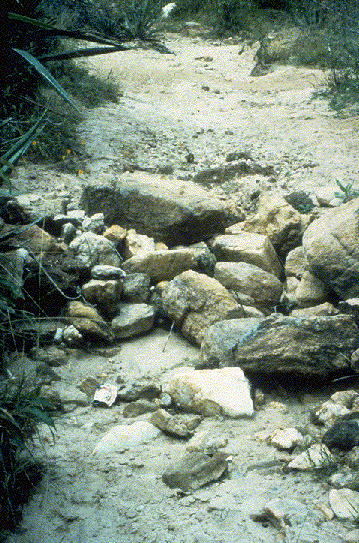
Gully formation. Here stones have been used to stabilise the gully. However, the back is too high, causing build-up of water.
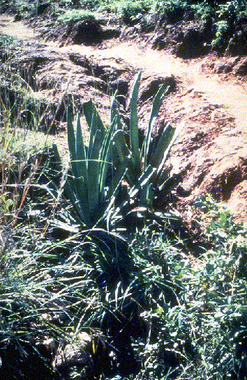
Gully stabilisation, using sisal (Agave sisalana sp.) and Acacia spp.
The estimated annual soil loss in the valleys is about 125 to 150 tonnes per hectare. Much of the sediment is collected in the main water reservoir of the catchment area. This 1.6 million cubic metre reservoir, built in 1982, will be completely silted up some between 1990 and 1995 if the present erosion and sedimentation is allowed to continue. This will be fatal for the development of agroforestry in Kakuyuni. Since the dam also provides drinking water for human consumption, this process is a major potential threat for further development of a wider region.
Notwithstanding the decline of natural production factors in the area, rapid socio-economic development encourages self-organisation and co-operation among the farmers, especially among the younger generations of farm families. The older and richer farmers are more self-reliant and independent and are seldom engaged in self-help co-operation.
Based on the interviews with farm families and land-use studies, the most important needs and wishes of the inhabitants of Kakuyuni were assessed. Major issues to be solved in the development plan are the shortages of productive land, fodder and fuel resources, and the increasing deterioration of the land through soil erosion, especially on grazing lands. These resources have to be used more efficiently in order to meet local production requirements. Limited productive land areas, wood shortages, and soil erosion are prevalent in the valleys and are therefore directly related with the cooperating, poorer, and second generation farming families. This group of farm families relies considerably on its livestock. This logically related to the conditions of their land. The sloping, rocky areas in the valley are mostly unsuitable for arable cropping, but are suitable for grazing. The farmers, however, need to practice some arable subsistence cropping. Therefore, they often clear the bush on slopes that are unsuitable for cropping and highly susceptible to soil erosion. Because their land area is relatively limited, the remaining areas are severely over-grazed, especially at the end of the dry season. Moreover, daily movement of the herds to the drinking places causes considerable damage to the standing vegetation and to the soils along the animal tracks.
Other needs mentioned during the interviews were organisational and economic production factors, such as local marketing potential, credit facilities, proper legislation and adjudication of land, availability of tools, seeds and seedlings, and the general lack of cash money. An additional consideration is that infrastructure conditions in Kakuyuni are poor. Main roads are unsafe for pedestrians and animals. Deep gullies along the roads form dangerous traps for all users.
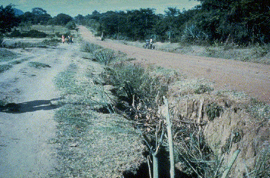
Erosion along the road from Kathama to Mbiuni. Water runs down from the undulating footslopes, and along the road. The erosive process is axacerbated by a lack of drains and vegetation.
erosive process is exacerbated by a lack of drains and vegetation.
Micro-climate in the catchment area is harsh. Roads, paths, and gathering places are often not shaded, and storms annually damage farm buildings. During most of the year, the availability of clean water is limited, especially in Katangi market. Finally, the larger farmers are accustomed to cultivating large areas for arable cropping and therefore always experience a lack of humanpower in the cropping season. Most of the farm families have not yet received any training in intensification of farming methods or in the application of agroforestry techniques. Consequently the development of local humanpower will be necessary for the adoptability and continuity of the proposed agroforestry interventions in Kakuyuni.